Wetland Trends and Upland Land Use

Understanding habitat change is critical to PHJV conservation planning efforts as this information is a primary input in our conservation planning models.

The PHJV utilizes a multi faceted approach to monitoring and estimating habitat and land use within the delivery area. Using a combination of detailed sample based datasets, agricultural lands inventory and agricultural census products, the PHJV has generated landscape level analysis of habitat change and habitat availability.

The Canadian Wildlife Service’s Prairie Habitat Monitoring Program provides the primary source of detailed wetland habitat change information within the PHJV.  This program assessed wetland and upland change habitat monitoring transects across the three Prairie Provinces at a 10-year interval.

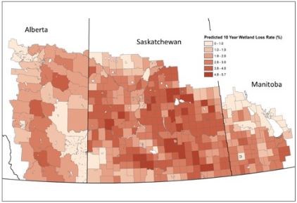
A good example of the use of habitat and land use data has been to inform the spatial variation in wetland loss across prairie Canada. We estimated Municipality-specific wetland loss rates by constructing statistical models relating sites-specific ECCC wetland loss sample based estimates to various landscape covariates associated with surveyed transects. Applying the best fitting statistical model of wetland loss allowed us to generate municipality-specific estimates of wetland loss (Figure A5-3). Using these estimates, we are able to estimate the impact of wetland loss on waterfowl carrying capacity of the region and target conservation objectives to where they will have the most impact.

The PHJV uses additional upland habitat change information from Statistics Canada Census of Agriculture data on land use at the Rural Municipality scale published every five years. The most recent Census of Agriculture (2021) can be accessed online from Stats Canada.

Beginning in 2009, these land use data have been supplemented by annual crop mapping (with 30m pixel spatial resolution) which provides additional upland habitat and land use information for both change detection and habitat distribution analysis. See AAFC Annual Crop Inventory

Going forward, the PHJV will seek additional sources of information on native grassland distribution, wetland habitat distribution and habitat change to inform all bird conservation models.

FIGURE A5-3. Estimated municipality-specific 10-year wetland loss rates. Loss rates were estimated as a function of the amount of cropland in the surrounding landscape.

A New Canada Wetland Inventory

Progress is also being made on a first nationwide wetland inventory for Canada which is already helping PHJV planners. See the Canadian Wetland Inventory.

Begun in 2002 by Environment and Climate Change Canada, Ducks Unlimited Canada, the Canadian Space Agency and the North American Wetlands Conservation Council Canada, this work is progressing across the country. To date, completed areas include much of southwestern Manitoba, southeastern and central Saskatchewan, parts of central and northern Alberta, and southern parts of the Western Boreal Forest – including many high priority PHJV conservation regions.